All 2026 Bookings FullNow Accepting Commissions for 2027Now Hiring — Contracted Drone VideographersStart the Conversation ↗

    Areas we serve / Crossfield

    Drone photography in Crossfield, Alberta

    Crossfield stands on open corridor ground with a clear fetch west to the foothills; the shallow Nose Creek line beside town is the only fold in the land, and it is not deep enough to slow a chinook.

    Free quote · No obligation · Advanced RPAS certified · Reply within one business day

    Does VeePo Media fly drones in Crossfield?

    Yes. VeePo Media flies drone photography and cinematography in Crossfield, Alberta. The airspace is Class G uncontrolled. Authorisation is not normally required in this airspace. Typical mobilisation from the Calgary base is 40 minutes.

    Crossfield at a glance.

    Operational facts for aerial work in Crossfield, Alberta

    Operational facts for aerial work in Crossfield, Alberta

    Base of operations
    Calgary, Alberta
    Drive time from base
    40 minutes
    Airspace
    Class G uncontrolled
    Nearest aerodrome
    Airdrie aerodrome
    Authorisation required
    No
    Flight status
    Flown routinely
    Certification
    Transport Canada RPAS Pilot Certificate — Advanced Operations
    Response
    Reply within one business day
    Airspace last verified
    2026-09-01

    Flying Crossfield: the ground truth.

    Crossfield stands on open corridor ground with a clear fetch west to the foothills; the shallow Nose Creek line beside town is the only fold in the land, and it is not deep enough to slow a chinook. A forecast that reads flyable from a sheltered Calgary yard can be at gust limits by the time it reaches 1 St W, and a shoot booked without regard to the wind loses its window on site.

    Crossfield bookings are set into the calm end of the day — usually first light, before the chinook builds — with the gust spread checked against the airframe's limits before mobilisation, and delivered in the standard turnaround.

    1. Airspace.

      Crossfield lies outside the charted Calgary-area control zones in uncontrolled Class G airspace, about 18 km from Airdrie aerodrome. No airspace authorisation is normally required. Before any flight, the exact site and altitude are checked against NAV Drone. This is a corridor-level assessment; the specific address is confirmed against NAV Drone before every flight.

    2. Terrain.

      Open corridor prairie on the survey grid, flat enough that grain bins and the Crossfield Agriplex read as skyline, with the shallow upper reach of Nose Creek threading past town.

    3. Wind.

      Chinook belt on open ground. Nose Creek is too shallow to shelter anything, so wind arrives at Crossfield at full strength; the calm hours of a chinook day are usually the early ones.

    4. Light.

      Green-up shows first along the Nose Creek line, then across the open quarters; late summer carries the corridor's wildfire-smoke risk to contrast, and winter turns the grid white almost overnight.

    5. On the ground.

      Launches from public land fall under Town of Crossfield rules for parks and pathways; staging from the client's own property with consent is the standard approach. Roughly 40 minutes north of the Calgary base — close enough for a same-day booking with a morning confirmation. Airdrie and Carstairs bracket it on the same run.

    Landmarks and communities: 1 St W · Railway Ave · Nose Creek · Crossfield Golf Club · Crossfield Agriplex

    From the reel

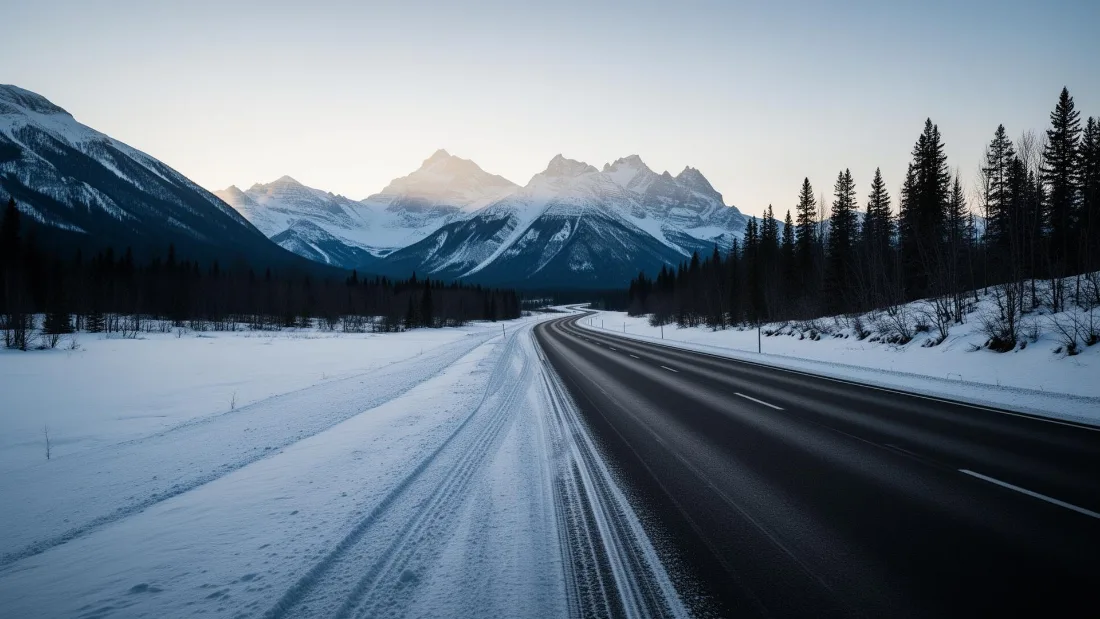
    Empty Icefields Parkway shoulder before sunrise, fresh tire tracks in light snow curving toward the Canadian Rockies.
    Empty Icefields Parkway shoulder before sunrise, fresh tire tracks in light snow curving toward the Canadian Rockies. — Icefields Parkway · 2025, from the VeePo Media reel. See the full gallery

    What gets shot in Crossfield.

    • agricultural
    • industrial yard
    • commercial retail

    Every subject above is delivered through the same aerial photography and cinematography services, scoped and quoted before the shoot is booked.

    What the research actually says.

    Industry standard

    The National Association of Realtors maintains dedicated guidance on commercial drone use in listing marketing, including the certification and airspace rules an operator must meet.

    Aerial media is an established part of listing marketing with real compliance requirements. The question is whether your operator meets them, not whether to use it.

    National Association of Realtors , 2025 · Primary source
    30% more

    McKinsey research cited across the inspection sector finds that organisations relying on manual inspection spend materially more on maintenance and safety than those using drone-based assessment.

    For a portfolio of assets, the inspection method is a recurring cost line, not a one-off purchase. The differential compounds annually.

    McKinsey & Company, cited by Averroes , 2025 · Industry aggregate

    Advanced certificate

    Transport Canada requires a Pilot Certificate for Advanced Operations to fly a remotely piloted aircraft in controlled airspace or near bystanders.

    Most of Calgary sits inside the CYYC control zone. An operator without this certificate cannot legally fly the majority of addresses in the city.

    Transport Canada , 2025 · Primary source

    Crossfield and what surrounds it.

    Relative positions of Crossfield and Airdrie Downtown, Carstairs, Cremona — not a navigational chart. Distances are great-circle approximations from the coordinates on each location page.

    How a Crossfield shoot runs.

    1. Scope and quote.

      Most Crossfield work is agricultural or industrial yard, and the shot list follows the subject. Mobilisation is stated separately from the fee.

    2. Airspace.

      Checked against NAV Drone from the address, not the postcode. Crossfield is class g uncontrolled, so authorisation is not normally required — but Airdrie aerodrome is 18 km away and its circuit is plotted regardless.

    3. Weather window.

      Chinook belt on open ground. Nose Creek is too shallow to shelter anything, so wind arrives at Crossfield at full strength; the calm hours of a chinook day are usually the early ones. Green-up shows first along the Nose Creek line, then across the open quarters; late summer carries the corridor's wildfire-smoke risk to contrast, and winter turns the grid white almost overnight.

    4. Shoot day.

      About 40 minutes from the Calgary base. Launch from the subject property with the owner's permission; launches from public land fall under Town of Crossfield rules for parks and pathways; staging from the client's own property with consent is the standard approach.

    5. Delivery.

      Edited files delivered digitally — no attendance required at any stage, which is how out-of-province owners of Crossfield property are served.

    Crossfield questions, answered.

    Does flying a drone in Crossfield require NAV CANADA authorisation?

    Normally, no. Crossfield lies in uncontrolled Class G airspace, outside the charted Calgary-area control zones and about 18 km from Airdrie aerodrome, so no airspace authorisation is required for routine work. The exact site and altitude are still checked against NAV Drone before every flight is confirmed.

    How does wind affect scheduling a drone shoot in Crossfield?

    More than most clients expect. The town stands on open corridor ground where a chinook arrives at full strength, and the shallow Nose Creek line offers no real shelter. Bookings are set into the calm end of the forecast — usually morning — with a fallback window held against the gusts.

    How quickly can a drone shoot happen in Crossfield?

    Mobilisation from the Calgary base is 40 minutes. Authorisation is not normally required here, so the binding constraint is the weather window rather than paperwork. Reply within one business day on any enquiry.

    The rules that govern a Crossfield flight

    Crossfield flight quote

    Tell me where, andwhat it needs to show.

    Free quote · No obligation · Advanced RPAS certified · Reply within one business day